Menu
A point on the map. The legacy of the glacier and a reminder of the historical past
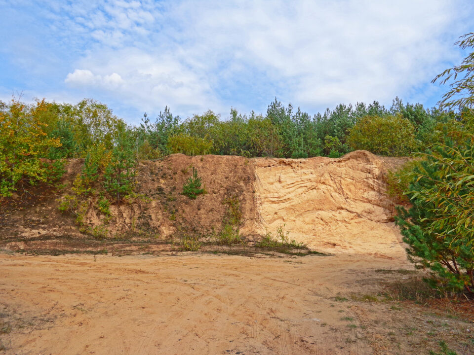
The Myślotyńska hill is a rare geographical object in Central and Southern Belarus, remaining from the ice age. Undoubtedly, it will be interesting to visit for history, nature, and industrial tourism enthusiasts. Once, a small village existed under the hill, and in the not-so-distant past, schoolchildren and young people gathered for meetings, competitions, and games, a sand quarry and an asphalt plant operated. And even now, no matter when you come, you will definitely meet someone. In the forest at the top of the hill, mushroom pickers wander. Someone will visit for the first time, and someone will come again to visit the memorial at the site of the burial of victims of genocide during the Great Patriotic War. And extreme sports enthusiasts seek adventure on their own, riding down the slopes of the quarry on bicycles or tubing.
The legacy of the glacial period
The Myślotyńska hill represents a drumlin (translated from German, it means "ridge") - a sandy hill of water-glacial origin. During the interglacial period, dead ice thawed for many years, and voids and cracks formed in its thickness, which, when filled with water, turned into peculiar lakes, rivers, and streams. In the lakes, solid sediments accumulated. In the summer, water flows brought sufficiently large remnants of mountain rocks: gravel, sand, and sandy loam. And in the winter, when the surface of such a lake was covered with ice, there was a sedimentation of small suspended particles in the water - loams and clays. A peculiar geological "Napoleon" cake was formed: layers of different thickness, mechanical composition, and color were repeatedly superimposed on each other. If, as geologists say, you "clean the wall" in a sand quarry, these layers will be clearly visible. If it were possible to count their number from the foot of the hill to its top, then, like the annual rings of a tree, you can approximately determine the time it took for the drumlin to form.
After the final thawing of the ice on the earth's surface, a sandy-gravel hill remained. Usually, drumlins have a rounded or elongated shape, their size is determined by the size of the lake in which they formed, and their height is determined by the duration and intensity of sediment accumulation. Single drumlins and their groups are found in the Belarusian Polessye - the northern part of our country, which was covered by the last ice sheet in history. On the rest of the territory of Belarus, drumlins have been preserved to a lesser extent: the farther south, the more rare they are.
On a large-scale topographic map of the Red Army from 1933, it is clearly visible that the Myslotinsky hill is round in plan and initially had two peaks. The highest of them has a mark of 175.7 meters, but in the second half of the 20th century, a quarry was created here and sand was mined. The modern topographic map shows the highest point of 172 meters in the northern part of the hill, where the second peak has been preserved. This refers to the absolute height, which is measured from sea level.
The hill rises 10-15 meters above the surrounding area.
Currently, sand mining is not carried out, but the deposit is on the list of those prepared for development. Its volume is measured at 1,402 thousand cubic meters, and the intended use is sand for earthworks.
"Geological windows" and visual biological aids
What attracts visitors to the quarries, to the point that a separate direction of industrial tourism has even emerged? First of all, there is really something to see here: the quarry itself, its steep slopes and dumps, the remains of industrial structures.
On the southern slope of the Myslotinsky quarry, there are preserved belts that possibly fixed it from landslides. Concrete blocks of various sizes are scattered across the bottom of the quarry and beyond its boundaries. Witnesses of former human activity, they now seem completely out of place in this location.
Much more interesting are the "geological windows" - exposures of rocks that provide an opportunity to see the internal structure and character of the layers of the upper layer of the earth's crust. On the northern wall of the quarry, on the right side, there is a significant steep slope. On it, even without prior cleaning, the alternation of layers of bottom sediments of a former glacial lake is visible. A relief pattern is even formed: sufficiently loose summer layers are blown away by the wind, as a result of which more durable winter sediments are transformed into ribbed protrusions. The bands of bottom sediments have a slight inclination from west to east. Such inclinations, or wavy patterns, are explained by the influence of western winds on the water surface, which was rarely calm at that time.
The industrial excavation was made to the very bottom of the sand deposits, the power of which exceeds ten meters. In small ravines, washed by water at the bottom of the quarry, moraine can already be seen - rocks crushed by ice and densely cemented with a large number of boulders of various sizes. The moraine is formed and transported by a glacier during its movement: first, it destroys the rocky rocks, and then, like a bulldozer, pushes the debris in front of it or transports it in the thickness of the ice or on its surface.
In general, the entire northern wall of the quarry presents a very interesting spectacle. It is fairly evenly divided vertically into two parts: dark and light. Unlike the steep right section, where the layering of yellow sandy deposits is visible, the left part of the wall is covered with a thin layer of dark soil and sparse vegetation. A difference of several degrees in slope is enough for water to be retained in the sand for some time and for pioneer plants to use it.
Even trees were able to take root and grow here, as if on level ground. The geological structure, soil formation processes, and evolution of vegetation are best studied or simply observed in a sandy quarry. This is the most genuine book of nature, open to anyone who wants to learn to read it.
A word to archaeologists and cartographers
During the 2009 field season, Belarusian archaeologists conducted reconnaissance in the Glusk and Minsk districts. The main goal of the work was to identify new Stone Age monuments in the Ptich River basin.
In the Glusk district, five previously unknown archaeological sites were discovered. One of them was named Glusk-4: this is the area from the Myslotinsky hill to Glusk along the Glusk-Dubrova road.
It seems that ancient people did not live on the hill itself, and what would they have done on this sandy hill? Having examined the quarry walls, scientists did not find a cultural layer (a layer of darker color, rich in remnants of human activity). However, on the slope of the hill, a fragment of handmade pottery with a large amount of fine grog in the clay paste was found. Mikhail Lashankov, who has worked many seasons in the Glusk district, dates the find to the early Iron Age. This pottery fragment could have ended up here by chance, or perhaps there was some kind of settlement here for a short time. In the field between the hill and the urban village, archaeologists collected 92 fragments of 18th-19th century ceramic pottery. The closer to the outskirts of Glusk, the more finds there are.
The fact that people once lived near Myslotinskaya hill is also confirmed by a military map from 1933. Along the southeastern slope of the hill (on the side where the memorial is located) four houses are marked in a row. Next to the name of the settlement - Padgor'ye - there is also a number 4, which clarifies the number of households. On a similar map from 1926, Padgor'ye is not marked, but on a map from 1940, it is still preserved. Apparently, this is the period of the village's existence. In the second half of the 1920s, when personal peasant farming was encouraged, many hamlets and small settlements emerged in our region. However, with the beginning of complete collectivization, almost all of them were liquidated, and the residents were relocated to villages where there were collective farm units (farms or brigades). By the start of the Great Patriotic War or immediately after it, Padgor'ye, most likely, no longer existed. When in March 1945, an Act on the crimes of German fascist occupiers in Glusk and the Glusk district was being compiled, the residents of the neighboring village of Khvastovichi gave testimony about the shootings on Myslotinskaya hill.
The path of suffering
From the central square of Glusk to Myslotinskaya hill, one can walk, without hurrying, in about forty minutes.
But how did this path seem to those who were led or taken here in early December 1941 to be deprived of life? Too short, because no one wanted to die, or very long, which only increased the suffering and took away one's mind from horror? In one day, the Hitlerites destroyed almost the entire Jewish population of Glusk.
As testified by the residents of Khvastovichi who were questioned, shootings on the hill during the German occupation were carried out almost daily. Among the victims were captured Red Army soldiers, partisans, underground fighters, and civilians who helped them. In the fall of 1943 and early 1944, in order to destroy the evidence of their crimes, the Hitlerites drove a group of prisoners of war and forced them to dig up and burn human remains. For this reason, it is impossible to accurately determine the number of Soviet citizens killed and buried in the sandy trenches.
According to various estimates, the number of victims of the genocide of the Belarusian and Jewish peoples on Myslotinskaya hill exceeds three thousand people.
Initially, a modest monument in the form of an obelisk to all the victims of fascism was erected in 1958. A separate monument to the Glusk Jews who died on that December day appeared in 2010. Its authors are architect Galina Levina and sculptor Maksim Pyatrukh. And in July 2022, the remains of two small children from the village of Amur were reburied next to the old obelisk. As the relatives reported, the three-year-old boy and his sister, who was just a few months old, were killed by the Hitlerites because their mother had hidden and did not give away Jewish children to be executed.
Around the Myslotinskaya hill, plowed fields stretch out. On the fresh furrow, the border between the dark cultivated soil and the yellow or white sand of the hill's foot is clearly visible. The slopes are gentle, but at the top, there are differences in height: steep descents and ascents, small depressions. Of course, it can't be compared to the heights of the Belarusian ridge, but it's no easier on the legs. Therefore, in an hour of wandering, you can get a good physical workout.
There's something to look at and think about here. And an original souvenir that the glacier from Scandinavia brought can be a found piece of pure pink field spar or specially water-polished quartz.
A. Yemelyanau
Photo by the author